Sandwith St / Upper Erne St Civic Design
A Sustainable Alternative for the P&T Site
The developer's application (WEB2956-26) proposes a monolithic 9-storey block with an effective plot ratio of ~3.9 and 73.4% site coverage[cite: 1, 2], running a commercial service roadway directly against our rear garden walls[cite: 2]. We propose a viable, policy-compliant design that introduces a mandatory 20-metre deep-soil green buffer, preserves historic residential scales, and integrates Dublin City Council’s statutory climate and greening mandates.
"Dublin City Council announced proposals to design an urban network of designated 'cooling spaces' and green corridors to address summer heat islands and climate adaptation in central municipal districts."
Aesthetic & Ecology Strategy
We propose restoring traditional Blue Bangor slate pitch roofs across Nos. 29–35 Upper Erne Street to reinforce the historic terrace grain[cite: 3]. The eastern wing of the new development is stepped down to 4 storeys in warm cross-laminated timber (CLT) to respect the domestic scale, with the 6-storey bar set back to the Sandwith Street and railway interfaces[cite: 1, 3].
Environmental Buffer
Inspect Policy →By reusing the established 1939 P&T facade portals on Sandwith Street for all internal loading and logistics[cite: 1], the eastern boundary is decoupled entirely. This creates an unencumbered 20m deep-soil green buffer featuring grass-crete surfaces, rain gardens, and birch canopies to meet DCC targets for microclimatic cooling, SuDS attenuation, and acoustic absorption.
Core Civic & Technical Design Requirements
Internalized Servicing via Repurposed Historic Facade Portals
All operational servicing—including daily deliveries, supply intake, and waste consolidation/removal—must take place entirely within the internal ground-floor footprint of the building. Vehicular circulation must utilize a one-way internal loop accessed via the northern gate and egressing via the southern gate of the 1939 P&T facade on Sandwith Street, while the central portal is civicly repurposed as the primary pedestrian entrance to the hostel.
Direct Sandwith Street Access for ESB Substation
The dedicated ESB substation must be accommodated within the ground-floor building envelope with direct, unhindered operational access directly from Sandwith Street, coordinated alongside the primary service vehicle entrance to the north of the site[cite: 1]. This ensures full compliance with standard ESB Networks 24/7 heavy vehicle access criteria directly from the public roadway.
Strict Prohibition of Infill Residential / Apartments at Southern Interface
Absolute restriction against any residential apartment blocks, mews dwellings, or habitable built structures between the Grand Canal Place apartment development and the immediate rear curtilage of Nos. 34 and 35 Upper Erne Street. This zone must remain 100% unbuilt deep-soil green buffer to protect the rear boundary, daylighting, and residential amenity of the most exposed historic terrace plots.
Absolute Prohibition of Subterranean Basement Excavation
Strict condition prohibiting any basement levels or deep subterranean excavations. Puncturing the high local water table risks catastrophic ground dewatering, loss of fine soils, and differential settlement beneath the shallow rubble stone foundations of the 19th-century residential terrace (Nos. 29–35 Upper Erne Street). Furthermore, inserting an impermeable subterranean concrete box creates a subsurface dam effect, displacing hydraulic pressure and groundwater surcharge directly into adjoining historic basements and domestic gardens.
Positive Features of the Alternative Scheme
Exemplary Policy-Compliant Density
By delivering a 2.23 Plot Ratio and ~57% Site Coverage, the alternative lands squarely within the optimal mid-band of the Dublin City Development Plan benchmarks for Z14 Regeneration zones (1.5–3.0 plot ratio; 50–60% coverage)[cite: 1]. It provides genuine compact urban brownfield renewal without relying on inflated site boundaries or overbearing bulk[cite: 1].
Robust Commercial Scale with Lower Risk
Providing 500 to 600 bed spaces across 6,480 m² of GFA, the scheme comfortably exceeds the scale of premier European city hostels while meeting Dublin's visitor accommodation needs[cite: 1]. Removing the complex subterranean basement eliminates millions of euros in ground dewatering, secant piling, and water-table risk, directly enhancing construction feasibility and financial delivery.
Streamlined Internal Operations & Street Safety
Reinstating the 1939 P&T one-way vehicle portals establishes a fully self-contained internal logistics circuit on Sandwith Street[cite: 1]. Daily linen intake, food supply, and commercial refuse collection take place entirely within an acoustic building enclosure, eliminating idling trucks, reversing hazards, and curbside congestion on public streets[cite: 1].
Municipal Climate Resilience & Deep-Soil SuDS
The 20-metre linear corridor serves as a dedicated municipal cooling space, directly delivering on the DCC Climate Action Plan 2024–2029. Deep unsealed soil, permeable grass-crete, and mature canopy trees actively mitigate the Urban Heat Island effect and attenuate stormwater on-site, relieving severe pressure on the regional combined sewer network.
Visualisations of the Civic Proposal
Click any image to open the full-resolution diagnostic viewer
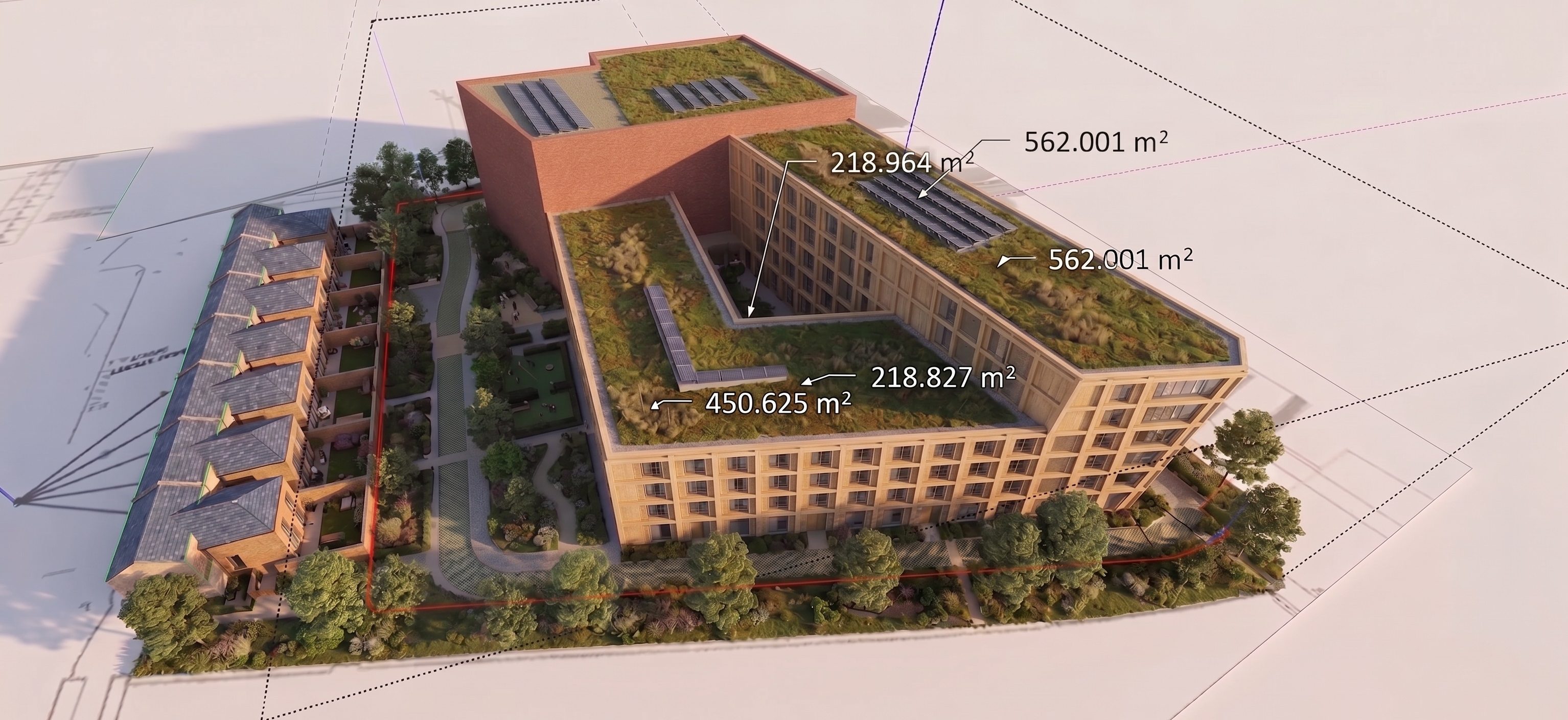 View 1: Stepped Geometry & GFA
Demonstrates the 4-storey eastern wing step-down and upper floors held back to the Sandwith Street frontage[cite: 1].
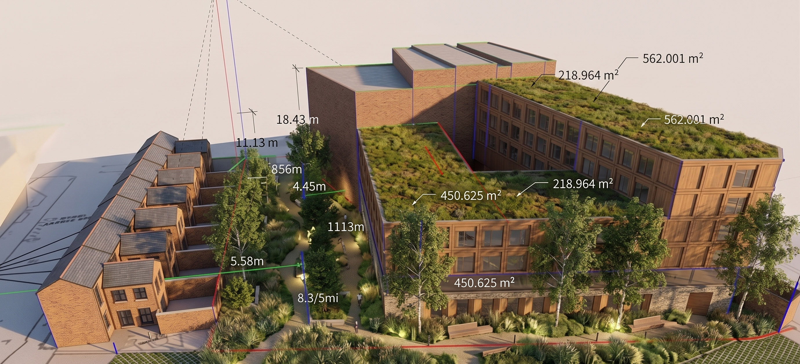 View 2: 20m Landscaped Buffer Detail
Features grass-crete emergency/fire transit, native tall grasses, perimeter seating, and mature birch trees.
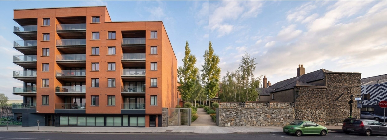 View 3: Street-Level Human Scale
Eye-level perspective showing how the 20-metre landscaped breathing space decouples the domestic terraces.
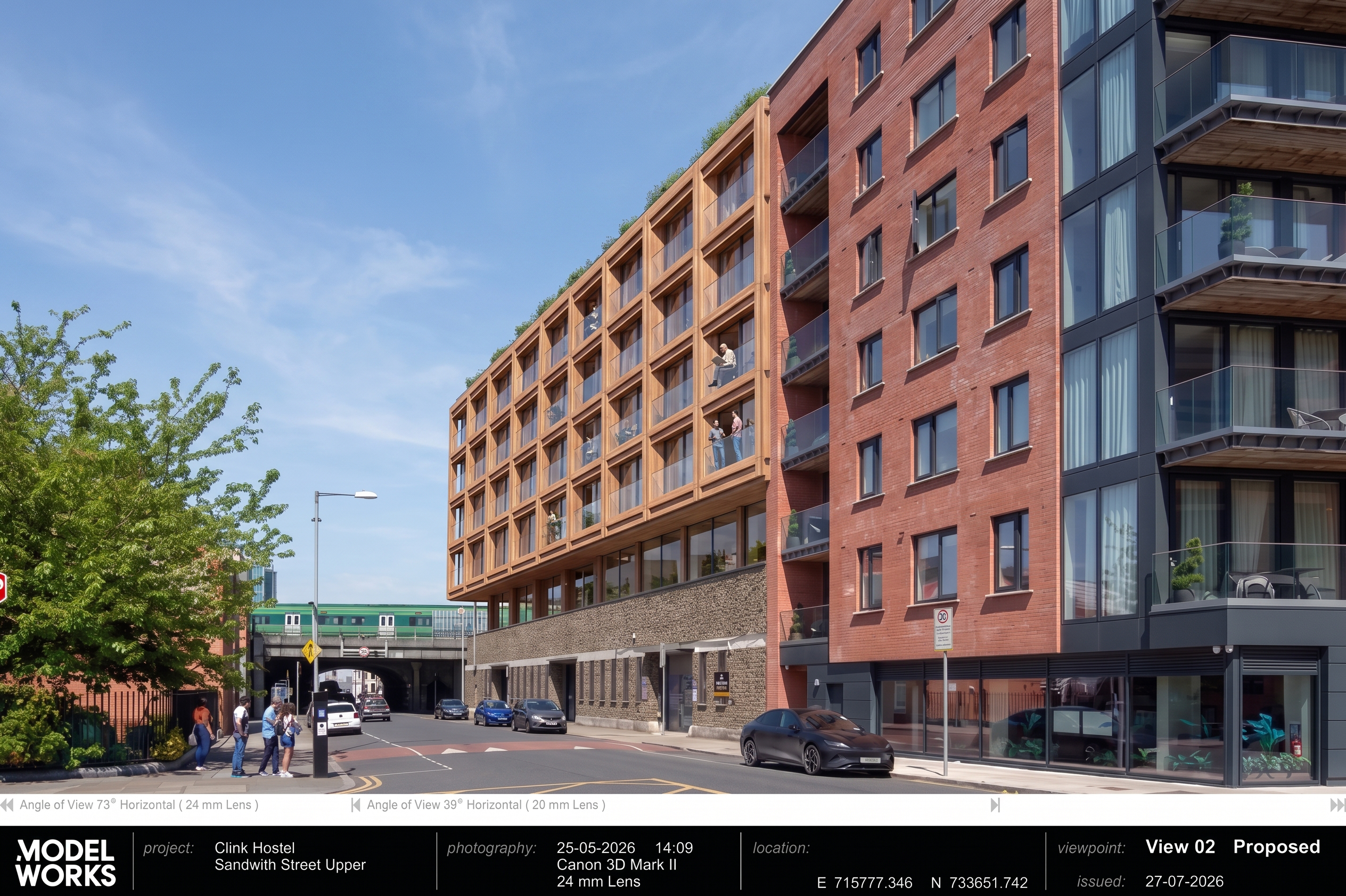 View 4: Sandwith St Photomontage
Retains the historic 1939 P&T facade base with set-back mezzanine and sustainable timber structural grid above.
Reconciled Schedule of Floor Areas
Exact component spatial breakdown supporting 2.23 Plot Ratio[cite: 1]
| Floor Level | Sandwith St Block[cite: 1] | Railway Elevation[cite: 1] | East Facing Block[cite: 1] | Courtyard Area[cite: 1] | Built Footprint[cite: 1] |
|---|---|---|---|---|---|
| Level 6 (Set back) | 562 m² | — | — | — | 562 m² |
| Level 5 (Set back) | 562 m² | — | — | — | 562 m² |
| Level 4 | 562 m² | 218 m² | 450 m² | — | 1,230 m² |
| Level 3 | 562 m² | 218 m² | 450 m² | — | 1,230 m² |
| Mezzanine Level | 562 m² | 218 m² | 450 m² | 218 m² | 1,448 m² |
| Ground Level | 562 m² | 218 m² | 450 m² | 218 m² | 1,448 m² |
- ✕Plot Ratio: ~3.9 (Calculated on Net Site using non-standard public footpaths)[cite: 1, 2].
- ✕Site Coverage: 73.4% (1,876 m² footprint on 2,556 m² net site)[cite: 1, 2].
- ✕Eastern Boundary: 0m buffer. 1-way commercial HGV roadway and 28-bin depot right on domestic curtilage[cite: 2].
- ✕Height / Massing: Monolithic 9-storey block; severe breach of BRE daylight/overshadowing guidelines for family gardens.
- ✕Acoustic Impact: Severe flanking noise from anti-social bin dragging and delivery idling.
- ✓Plot Ratio: 2.23 (Gross) / 2.53 (Net) – within Regeneration area standard (1.5–3.0)[cite: 1].
- ✓Site Coverage: 57.0% (1,448 m² footprint on 2,556 m² net site) – within standard (50–60%)[cite: 1].
- ✓Eastern Boundary: Mandatory 20-metre deep-soil linear green buffer and SuDS corridor.
- ✓Height / Massing: Stepped: 4 storeys facing terrace; 5th/6th storeys pulled back to Sandwith St & Railway[cite: 1, 3].
- ✓Acoustic Impact: Decoupled. Logistics internalized via historic P&T facade portals on Sandwith St[cite: 1].
| Standard Planning Metric | DCC Development Plan Benchmark | Developer Scheme | Civic Alternative |
|---|---|---|---|
| Plot Ratio | 1.5 – 3.0 (Regeneration Z14) | ~3.9[cite: 1] | 2.23[cite: 1] |
| Site Coverage | 50% – 60% (Regeneration Area) | 73.4%[cite: 1, 2] | 57.0%[cite: 1] |
| Gross Floor Area (GFA) | Site contextual | 10,603 m²[cite: 1] | 6,480 m²[cite: 1] |
| Eastern Setback | Adequate separation for amenity | Vehicular Access | 20m Green Buffer |
Consolidate Community Opposition
We are consolidating a collective multi-signature observation to Dublin City Council to request this alternative layout as a formal condition of permission. If you support incorporating the mandatory 20-metre deep-soil buffer, please sign on: